Post
U.S. EPA Offers “How’s My Waterway” App
Fishing Conservation, Fishing Games, Apps & Mobile theangler PM
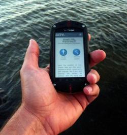
Have you ever wondered if the waters you are fishing are clean and healthy? Now you can get the answer through How’s My Waterway, a new app from the US Environmental Protection Agency (EPA). How’s My Waterway allows users to quickly find information on the condition of streams, lakes and other waters anywhere in the US using their smartphone, tablet or desktop computer.
One-click provides instant access to the EPA’s extensive database of water quality monitoring reports. Click the Choose a Location button to manually search for waters anywhere in the US. Click the Use My Location button and the site will use your smart device’s GPS to identify all waterways within five miles of your location. In plain language, the site will tell you if your local waters are polluted or not, what kind of pollutants were found, and what actions the EPA and state are taking to reduce or eliminate the pollution.
To access How’s My Waterway and for instructions on how to download a shortcut onto your mobile device go to www.epa.gov/mywaterway. Check out the condition of your local waters today! About How’s My Waterway
How’s My Waterway was designed to provide useful public information based on data that States have provided to EPA on a two-year cycle. More recent or more detailed water information may exist that is not yet available through EPA databases or other sources. Information presented on this site cannot be relied upon to create any legal rights, substantive or procedural, enforceable by any party in litigation with the United States or third parties. How’s My Waterway does not change or substitute for any statute, regulation, EPA decision or position. This site may be revised periodically without public notice.
About pollution reporting
The Clean Water Act requires states, territories and authorized tribes (states for brevity) to monitor water pollution and report to EPA every two years on the waters they have evaluated. This process is called assessment. Part of this process is deciding which waters do not meet water quality standards because they are too polluted. These degraded waters are called impaired (polluted enough to require action) and are placed on a State list for future actions to reduce pollution. How’s My Waterway local information includes whether and when a waterway was assessed, what pollution may exist, and what has been done to improve conditions.
About water quality information
EPA’s water databases are the largest single, national source of information about reported water quality problems and efforts to fix them. Other information not directly accessible with this search tool exists in federal, state, local, and private sources. Many of these sources appear among the Related Links. However, water quality monitoring is limited. Older assessment information may no longer be accurate. Many waters in the US have not been assessed and there is no information reported about their condition. A waterway that has not been assessed may or may not be polluted, and a polluted waterway may have more pollutants than those that were measured and reported.
About pollution categories
A single waterway can have one or more types of pollution. When States report polluted waters, they put them in different categories. EPA uses 34 major categories of water pollution in its national summary. There are more detailed subcategories within each of these. For example, the category “Metals” may include lead, cadmium, zinc, or copper as water pollutants. How’s My Waterway provides simple descriptions of each major category, where the pollution comes from, its effect on the environment and on beneficial waterway uses, what citizens can do to help, and where to find more information.
Pollution categories summary document (PDF) (20 pp, 557K, About PDF).
About what’s being done
Reporting water pollution leads to action for improvement. Two major types of action taken under the Clean Water Act are TMDL cleanup plans and nonpoint pollution control projects. Tens of thousands of polluted waters now have a Total Maximum Daily Load (TMDL) cleanup plan, which is a ‘reduced pollution diet’ designed to help waters become healthy again. The TMDL serves as a basic game plan for a variety of different restoration activities, including polluted runoff control projects. EPA provides funds to States to help control nonpoint pollution, which comes generally from landscape runoff rather than a single discharge pipe. Due to progress in cleaning up wastewater discharges, most remaining water pollution now comes from nonpoint sources. How’s My Waterway identifies whether a polluted waterway has TMDL cleanup plans or polluted runoff control projects.